Dreaming of stepping from your lanai onto your boat and cruising to open water in minutes? If you’re looking at Royal Harbor or nearby Port Royal in Naples, “Gulf-access” is more than a buzzword. You want clear, practical answers about routes, depth, tides, clearance, and what to inspect at the dock. This guide explains what Gulf-access living really means here and how to verify the details before you buy. Let’s dive in.
What Gulf-access means here
“Gulf-access” in Royal Harbor means your private or shared dock connects to short canals that open into Naples Bay, then out the local inlet to the Gulf of Mexico. You keep the boat at the house, not on a trailer, and reach open water with a simple cruise. The exact route, depth, and speed limits depend on your specific canal and the bay. Always confirm the path using current charts and local guidance.
When you see “direct” Gulf access, verify there are no fixed low-clearance bridges on your route. Ask if the dock sits on a private canal or basin, whether slips are shared, and if any association rules limit boat size or motor type. Review any available surveys or recorded depths for the canal segment serving the property.
How waterways work
Canals and basins
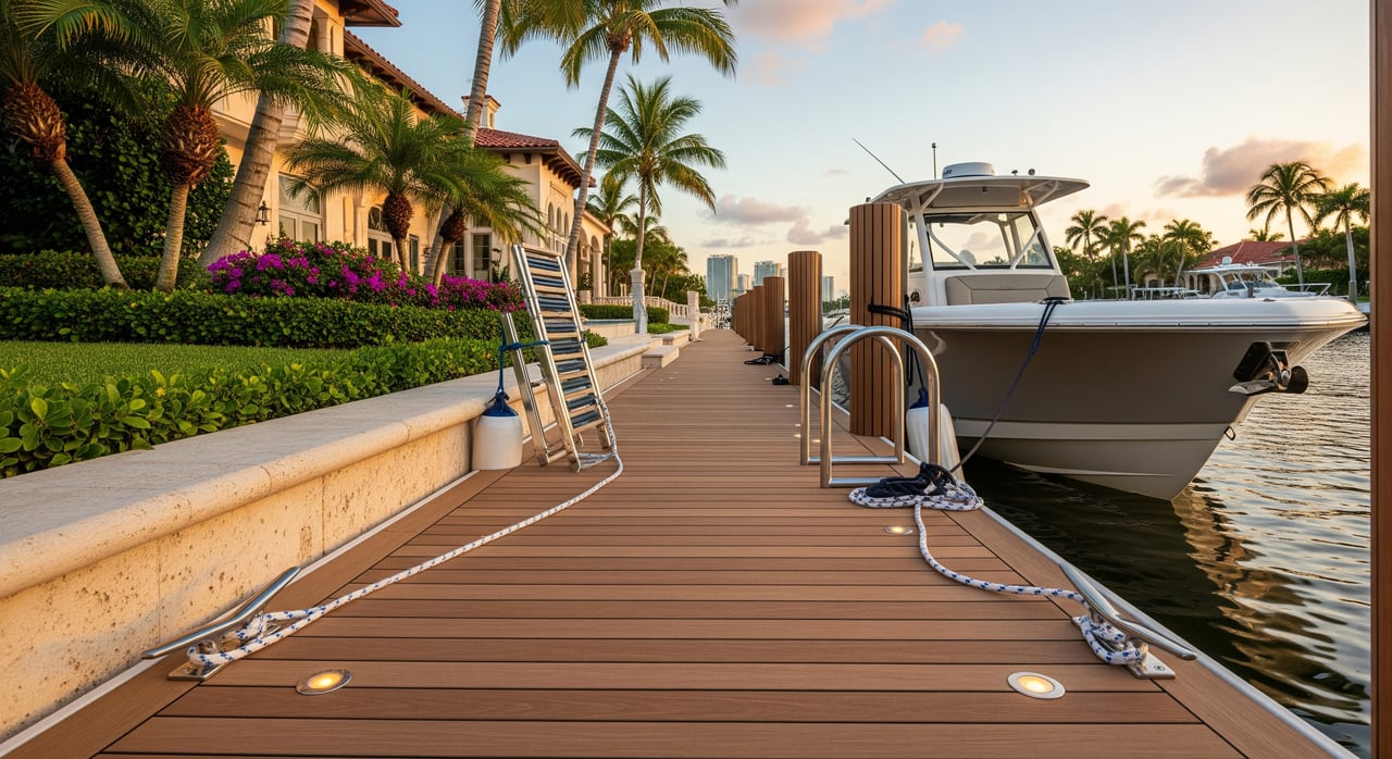
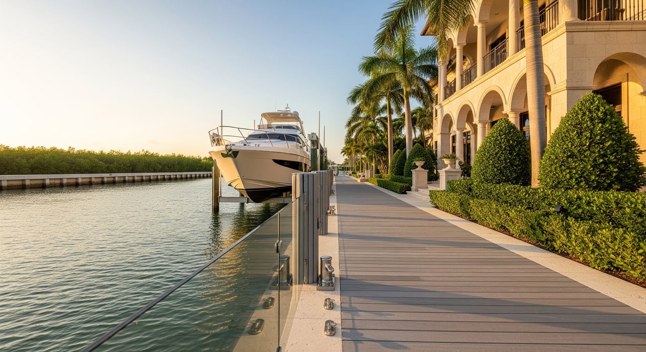
Royal Harbor’s canals are short, man-made channels leading to Naples Bay. Some homes face a protected basin rather than a straight canal. Most luxury lots have seawalls with fixed docks and finger piers designed for center consoles and similar boats.
Depth and tides
These waters are tidal, and depths can vary by canal, dredging history, and sedimentation. Many residential canals can run shallow at lower tides compared to the Gulf. Use a current chart and check predicted low tides at the NOAA Naples Tides & Currents station to gauge conservative draft limits for your vessel.
Environmental protections
Seagrass beds and mangroves are protected resources. Permits are typically required for dredging, dock expansions, or mangrove trimming. Review rules with the county and state, and plan to avoid prop scarring or anchoring in seagrass. You can start with FWC boating regulations for marker and zone guidance.
Estimate time to the Gulf
You can estimate your run with simple math:
- Measure nautical miles from the dock to the inlet or first offshore waypoint using a chart or plotter. The NOAA nautical charts site is a good reference.
- Divide distance by your cruising speed to get hours, then convert to minutes. For example, 1.0 nm at 20 knots is about 3 minutes underway.
- Add 5 to 15 minutes for leaving the dock, no-wake segments, and inlet congestion.
- Factor in tide and sea state. Running against current or wind can slow you.
In Royal Harbor and Port Royal, many docks are only a short run to Naples Bay and the inlet. For typical powerboats, it often ranges from a few minutes to under 15 minutes once you account for local speed zones and your starting canal. Confirm your actual distance and any posted restrictions on your chosen route.
Bridges and clearance
Most Gulf-access neighborhoods here are planned to avoid low fixed bridges on primary routes to the Gulf. Even so, verify the exact path for your vessel’s air draft. Cross-check bridge notes on NOAA nautical charts and observe the route at your expected tide level.
If you run a tall flybridge or a sailboat, compare your highest fixed point to charted clearances and tide extremes. Also review the U.S. Coast Guard Local Notices to Mariners for temporary restrictions.
Docks, lifts, and checks
You will see fixed docks on pilings with finger piers and, less often, floating sections. Common lift setups range from 4,000 to 12,000 pounds for runabouts and center consoles, with larger custom lifts on some estates. Many private docks comfortably handle boats in the 25 to 50 foot range, and select properties are outfitted for larger yachts, subject to depth and beam.
During due diligence, inspect lift rating plates, cables, motors, and electrical pedestals. Look closely at the seawall for spalling or settlement. Ask for any permits or inspections tied to the dock, lift, or seawall, as well as maintenance or replacement records. For new work or upgrades, check with Collier County Building & Permitting and the Florida DEP Submerged Lands and ERP program on permit requirements.
Rules and storm prep
Expect marked speed and no-wake zones in residential canals and parts of Naples Bay. Follow posted markers and confirm current zones through FWC boating regulations. Anchoring can be restricted in seagrass and protected areas. Use moorings where provided and avoid disturbing sensitive habitats.
Plan for legal waste management and pump-outs if you spend extended time aboard. For hurricanes, many owners arrange haulout or secure boat and lift with chafe protection and tie-downs. Check policy requirements and consider elevation and flood exposure using the FEMA Flood Map Service Center.
Buyer due diligence checklist
Documents and confirmations to request:
- Dock and seawall survey and as-built site plan.
- Chart excerpt or coordinates showing your route to the inlet.
- Measured water depth at the dock entrance at predicted low tide.
- Lift specification plate photo and maintenance records.
- Permits for dock, seawall, and any past dredging; any code items.
- Association rules on boat length, horsepower, trailer storage, or overnight mooring.
- Insurance claims history related to dock, seawall, or marine incidents.
- Dredging or access agreements for shared canals.
- Photos or inspection reports of the seawall and pilings, if available.
- Nearest marinas for fuel, haulout, and repairs.
On-site inspections and tests:
- Walk the dock at low tide, note bottom composition, and check approach depth.
- Inspect lift cables, motor, and electrical with a qualified marine electrician.
- Confirm overhead clearance at mean high water for taller vessels.
- If possible, run a timed test trip to the inlet during your typical boating hours.
- Hire a local marine surveyor for the dock, lift, and seawall.
Local knowledge to gather:
- Recent shoaling and dredging history on your canal and entrance.
- Typical transit times and seasonal water level patterns.
- Any common navigational hazards like temporary markers or crab traps.
- Recommended haulout yards, mechanics, and fueling options.
Beyond navigation: value and resale
Waterfront value hinges on more than the view. Depth at low tide, permitted boat size, lift capacity, and the condition of the seawall and dock can shape your insurance options and resale market. Expect ongoing costs for lift service, decking, electrical, and periodic dredging in some canals. If your dream boat outgrows a private slip, you can evaluate local marina or drystack alternatives.
Work with a local advisor
Choosing the right Gulf-access property is part boating, part real estate, and all about details. You want a partner who understands Naples’ canals, permits, and lifestyle nuances as well as the luxury market. With a boutique, single-advisor approach backed by Premier Sotheby’s global reach, you get responsive, concierge-level guidance plus strong market exposure when you sell.
Ready to pinpoint the homes that truly fit your boat and your life? Let’s connect for a curated list and a dock-and-depth review before you write an offer. Reach out to Unknown Company to get started.
FAQs
What does Gulf-access mean in Royal Harbor?
- It means your dock connects by short canals to Naples Bay and then the local inlet, so you can reach the open Gulf without trailering, subject to posted zones and verified depths.
How long from a Royal Harbor dock to open Gulf?
- Many homes are a short run to the inlet, often a few minutes to under 15 minutes for powerboats, depending on exact location, speed zones, tide, and traffic.
Are there low bridges between Royal Harbor and the Gulf?
- Many routes avoid fixed low bridges, but you should verify your exact path and air draft with NOAA nautical charts and a visual check at expected tide.
How do I estimate my transit time in Naples?
- Measure nautical miles on a chart, divide by your cruising speed, then add time for no-wake segments and maneuvering; confirm current zones via FWC boating regulations.
What dock and lift sizes are typical in Port Royal and Royal Harbor?
- Many private docks suit boats in the 25 to 50 foot range, with select estates outfitted for larger yachts; suitability depends on slip length, beam, lift rating, and verified depth.
Do I need permits to modify a dock or seawall in Collier County?
- Most dock, lift, and seawall work requires county permits, and dredging or mangrove work often needs state or federal approvals; start with Collier County Building & Permitting and Florida DEP.
Where can I check local boating notices for Naples?
- Review the U.S. Coast Guard Local Notices to Mariners for temporary restrictions, dredging updates, and safety advisories.
How do I account for tides at my dock?
- Compare your boat’s draft to depths measured at predicted low tide using the NOAA Naples tide station, and use a conservative safety margin.